


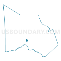
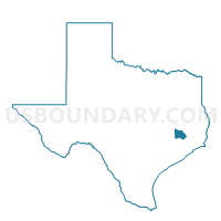
Voting District 0069, Montgomery County, Texas
About
Outline

Summary
| Unique Area Identifier | 675973 |
| Name | Voting District 0069 |
| County | Montgomery County |
| State | Texas |
| Area (square miles) | 1.55 |
| Land Area (square miles) | 1.55 |
| Water Area (square miles) | 0.00 |
| % of Land Area | 100.00 |
| % of Water Area | 0.00 |
| Latitude of the Internal Point | 30.21584540 |
| Longtitude of the Internal Point | -95.51364500 |
Maps

Graphs
Select a template below for downloading or customizing gragh for Voting District 0069, Montgomery County, Texas


Neighbors
Neighoring Voting District (by Name) Neighboring Voting District on the Map
- Voting District 0034, Montgomery County, TX
- Voting District 0070, Montgomery County, TX
- Voting District 0075, Montgomery County, TX
- Voting District 0078, Montgomery County, TX
- Voting District 0081, Montgomery County, TX
Top 10 Neighboring County Subdivision (by Population) Neighboring County Subdivision on the Map
- Southeast Montgomery CCD, Montgomery County, TX (318,202)
- Montgomery CCD, Montgomery County, TX (50,994)
Top 10 Neighboring Place (by Population) Neighboring Place on the Map
Top 10 Neighboring Unified School District (by Population) Neighboring Unified School District on the Map
Top 10 Neighboring State Legislative District Lower Chamber (by Population) Neighboring State Legislative District Lower Chamber on the Map
Top 10 Neighboring State Legislative District Upper Chamber (by Population) Neighboring State Legislative District Upper Chamber on the Map
Top 10 Neighboring 111th Congressional District (by Population) Neighboring 111th Congressional District on the Map
Top 10 Neighboring Census Tract (by Population) Neighboring Census Tract on the Map
- Census Tract 6906.01, Montgomery County, TX (20,181)
- Census Tract 6905, Montgomery County, TX (7,570)
- Census Tract 6909, Montgomery County, TX (4,459)
- Census Tract 6908, Montgomery County, TX (4,237)